

| The World Factbook | ||


|
Ashmore and Cartier Islands |

|

|
| Introduction | Ashmore and Cartier Islands |
|
Background:
|
These uninhabited islands came under Australian authority in 1931; formal administration began two years later. Ashmore Reef supports a rich and diverse avian and marine habitat; in 1983, it became a National Nature Reserve. Cartier Island, a former bombing range, became a marine reserve in 2000. |
| Geography | Ashmore and Cartier Islands |
|
Location:
|
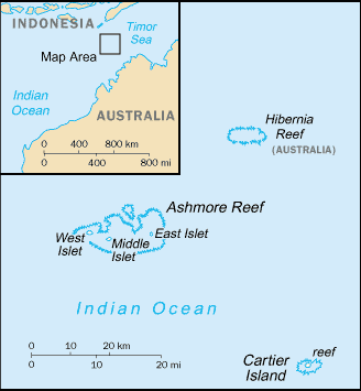
Southeastern Asia, islands in the Indian Ocean, midway between northwestern Australia and Timor island |
|
Geographic coordinates:
|
12 14 S, 123 05 E |
|
Map references:
|
Southeast Asia |
|
Area:
|
total: 5 sq km
land: 5 sq km water: 0 sq km note: includes Ashmore Reef (West, Middle, and East Islets) and Cartier Island |
|
Area - comparative:
|
about eight times the size of The Mall in Washington, DC |
|
Land boundaries:
|
0 km |
|
Coastline:
|
74.1 km |
|
Maritime claims:
|
territorial sea: 12 nm
contiguous zone: 12 nm exclusive fishing zone: 200 nm continental shelf: 200-m depth or to the depth of exploitation |
|
Climate:
|
tropical |
|
Terrain:
|
low with sand and coral |
|
Elevation extremes:
|
lowest point: Indian Ocean 0 m
highest point: unnamed location 3 m |
|
Natural resources:
|
fish |
|
Land use:
|
arable land: 0%
permanent crops: 0% other: 100% (all grass and sand) (2005) |
|
Irrigated land:
|
0 sq km |
|
Natural hazards:
|
surrounded by shoals and reefs that can pose maritime hazards |
|
Environment - current issues:
|
illegal killing of protected wildlife by traditional Indonesian fisherman, as well as fishing by non-traditional Indonesian vessels, are ongoing problems |
|
Geography - note:
|
Ashmore Reef National Nature Reserve established in August 1983; Cartier Island Marine Reserve established in 2000 |
| People | Ashmore and Cartier Islands |
|
Population:
|
no indigenous inhabitants
note: Indonesian fishermen are allowed access to the lagoon and fresh water at Ashmore Reef's West Island; access to East and Middle Islands is by permit only |
| Government | Ashmore and Cartier Islands |
|
Country name:
|
conventional long form: Territory of Ashmore and Cartier Islands
conventional short form: Ashmore and Cartier Islands |
|
Dependency status:
|
territory of Australia; administered by the Australian Attorney-General's Department |
|
Legal system:
|
the laws of the Commonwealth of Australia and the laws of the Northern Territory of Australia, where applicable, apply |
|
Diplomatic representation in the US:
|
none (territory of Australia) |
|
Diplomatic representation from the US:
|
none (territory of Australia) |
|
Flag description:
|
the flag of Australia is used |
| Economy | Ashmore and Cartier Islands |
|
Economy - overview:
|
no economic activity |
| Transportation | Ashmore and Cartier Islands |
|
Ports and terminals:
|
none; offshore anchorage only |
| Military | Ashmore and Cartier Islands |
|
Military - note:
|
defense is the responsibility of Australia; periodic visits by the Royal Australian Navy and Royal Australian Air Force |
| Transnational Issues | Ashmore and Cartier Islands |
|
Disputes - international:
|
as the closest Australian territory to Indonesia, these islands became the target of human traffickers for the landing of illegal immigrants; in 2001, the Australian government removed these islands from the Australian Migration Zone making illegal arrivals ineligible for temporary visas and entry into Australia |
|
This page was last updated on 18 December, 2008 |